You are here
Azimuth / Elevation graphs are available !
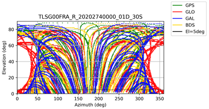
Azimuth / Elevation graphs are now available on REGINA stations. They represent the tracking of GPS, GLONASS, GALILEO and BEIDOU constellations for a given day by displaying the elevation of the satellites as a function of the azimuth. Data are extracted from the Rinex3 daily quality files. They are generated by the mission center with G-NUT/Anubis tool developed by Pecny Geodesy Observatory (GOP). These graphs allow for a comparison between a reference day and current day - 1 and, for example, to note on low elevations any changes in the site environment (new building, vegetation, ...). By default, the reference day is the one corresponding to the last day of the yearly operational increment (2019-05-31). It could also be the day of the station installation or the day of an antenna replacement in these specific situations.